This video shows a long linear mound. Sorry about the quality of the video. The mound is snow covered and the brush around the mound made taping difficult. I wanted to document this type of linear mound. It is 40 feet long and points in a NW to SE direction. There is a round stone pile 20 feet East of this and these piles are part of a line of stone piles that extend for 3/4s of a mile.
Friday, December 28, 2007
Thursday, December 27, 2007
New Area
I think I confirmed a new area where stone piles are located this week. Someone once told me that there are Native stone piles located at the Canandaigua on ramp to the Thruway. Several stone piles are clearly visible in the woods to the East between the toll both and the Thruway. Now that the leaves are gone a small round pile and a long mound are visible. Because of their shape, the way that they are clustered, and the fact that the land is too wet to be farmed, I do believe they are of Native origin. I plan on making a video of a similar long mound tomorrow. Anyone getting on the Thruway here a traveling West can see these pile from their vehicle as they drive by.
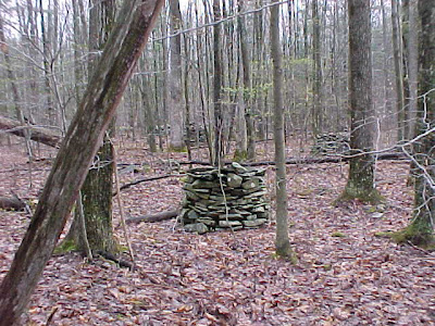
Tuesday, December 4, 2007
Good New Information
I think the real power in a blog like this is that it has the ability to connect people with a shared interest. There is a loosely connected network of people all along the east coast that have found the types of stone structures I've found in this area. When you connect all of these loose threads together a much clearer vision of this archaeological phenomena appears.
I've been communicating with Norman M. recently and he has pointed out other important places on the Internet where sites have been documented. His Neara article on Rochester Vermont documents an area where a large number of well preserved cairns exist. He also shared a good PowerPoint slideshow that documents large cairns on Overlook Mountain (click on the link at the bottom)in New York State.
I've been communicating with Norman M. recently and he has pointed out other important places on the Internet where sites have been documented. His Neara article on Rochester Vermont documents an area where a large number of well preserved cairns exist. He also shared a good PowerPoint slideshow that documents large cairns on Overlook Mountain (click on the link at the bottom)in New York State.
Monday, December 3, 2007
Rhinebeck New York
Norman M. sent me a link to an excellent video that documents a cairn site in Rhinebeck New York. These cairns remind me of the ones located here in the Fingerlakes area.
Friday, November 30, 2007
Interesting Web Site
Surfing the Net I found a digital document that documents the first nations practice of making stone cairns.
Sunday, October 28, 2007
10/28/07

Went for a hike and marked a few new stone piles. Judy was happier than she looks in the picture. Most of these piles were small but showed definite signs of stacking.
Thursday, October 25, 2007
Update
I've been very busy since school started and I have not had time to post new information or get out into the woods. Hunting season is gearing up so I will probably wait until December before I venture out into the woods again. I have been hearing rumors of a number of sites located throughout New York State where native stone structure can be found. I will be adding to this post as time allows listing places where these structures are rumored to have been found. If anyone reading this blog has time to check out these site and send a reply I would appreciate the information.
This account is from Mason C. Winfield's web site "Monsters From The Mound"
T. Apoleon Cheney notes (in Illustrations of the Ancient Monuments of Western New York) that a twelve-foot high elliptical mound above Cattaraugus County’s Conewango Valley held eight big skeletons. Most crumbled, but a thigh bone was found to be 28” long. Exquisite stone points, enamelwork, and jewelry (like that of Mexico or Peru) were also unearthed in the area. The mound looked like those of the Old World.
http://www.usgennet.org/usa/ny/county/allegany/countyhistory/TheForbiddenTrail/TheForbiddenTrail.htm
Zeisberger’s journal for October 3rd reported “about noon we arrived at Assinesink (Corning) previously burnt and laid waste by the Mohawks. Curiosities in the shape of pyramids of stone are here to be seen. From them this place derives its name. The two largest are over 2 or 3 stories high. In some cases a flat stone rests on the top as if to keep off the rain- whether these pyramids are natural or made by human hands, I will leave to others to decide. Here the Tiaogee (Chemung) divides into two branches, one goes north into the land of the Senecas, the other along which we pursued our way extends towards the west. We Passed Knacto (Painted Post) and Woapassique (Addison), two old Indian towns. The way was very wild and difficult.” (The stone piles mentioned by Zeisberger were just west of Gibson until the DL&W RR Was built. Most of them were blasted apart then to make room for the railroad tracks.)
http://www.dec.ny.gov/lands/38834.html
There is a line of small stone piles located in the Cinnamon Lake State Forest near Corning New York. I have seen these stone piles and they are Native in origin.
Another area that I have heard rumors of stone piles is Happy Valley just North of Syracuse. I someone told me you see hundreds of them along the snowmobile trails. I would love to check this out. The Salmon River runs through this area and it would make sense that there would be stone piles in this area.
Another rumored spot is Klipnocky State Forest. A freind of mine was geocaching and said he saw a number of stacked stone piles in this area. These are the possible coordinates N 42° 22.793 W 077° 48.064 for the location of one of the stone piles.
If anyone has information about these areas or would like to add to the list please contact me.
Wednesday, September 19, 2007
Spiritual Landscape
One of my goals in creating this blog was to connect people that share an appreciation of the land we live on. I have been pleased with the response from readers. One of the people that I have meet is Madis Senner. Madis is interested in connecting spiritually with the land. He has created a web page that outlines his beliefs and included his interpretation of the Clark Gully and Bare Hill sites. Please visit his web site.
http://www.jubileeinitiative.org/sacredbarehill.html
http://www.jubileeinitiative.org/sacredclarksgully.html
http://clarksgully.blogspot.com/
Sorry! I can't get Blogger link function to work.
http://www.jubileeinitiative.org/sacredbarehill.html
http://www.jubileeinitiative.org/sacredclarksgully.html
http://clarksgully.blogspot.com/
Sorry! I can't get Blogger link function to work.
Tuesday, September 11, 2007
New Blog
My new friend Kathy shares my interest in native stone structures. She lives East of of my neck of the woods (whatever that means). She is researching the stone structures in the Afton area. There seems to be a lot of well preserved cairns in this area. Please visit her blog and check out the pictures and information that she has posted.
http://twoheadwaters.blogspot.com/
http://twoheadwaters.blogspot.com/
Platform Cairn
There seem to be four basic types of stone piles in this area. This video documents one particular type. It is a round platform cairn. They are usually between 15 and 30 feet in diameter. They are often found on hillsides facing the sun. In the video I say that they are stacked better on top. What I should have said was that the up hill side of the cairn is usually well stacked and taller than the downhill side of the cairn. Maybe gravity causes this effect or maybe they were built this way to maximize sun exposure.
Thursday, September 6, 2007
The Old Fort on Bare Hill
I was surfing the web and came across an old article by David Robinson. He was the person that really enlighten me to the fact that these stone structures were still lying quitely thought the woods of Western New York. This article outlines his views on the people that lived in this area so long ago.
http://www.crookedlakereview.com/articles/101_135/103spring1997/103robinson.html
http://www.crookedlakereview.com/articles/101_135/103spring1997/103robinson.html
Tuesday, September 4, 2007
Two Faced Stone
I thought this was interesting.
http://www.moillusions.com/2007/09/mysteryous-two-faced-rock.html
It looks like a lot of the carvings that I have seen associated with the mound building cultures.
The idea of a two faced stone reminded me of this stone found near the end of my driveway a few years ago.


I feel the need to point out that I am not suggesting this image is prehistoric. Whoever made it created a fascinating image and left it in a spot that has been documented as a native burial site.
http://www.moillusions.com/2007/09/mysteryous-two-faced-rock.html
It looks like a lot of the carvings that I have seen associated with the mound building cultures.
The idea of a two faced stone reminded me of this stone found near the end of my driveway a few years ago.

I feel the need to point out that I am not suggesting this image is prehistoric. Whoever made it created a fascinating image and left it in a spot that has been documented as a native burial site.
Sunday, September 2, 2007
And more from the Masonville Afton area
Norman and Kathy have both sent in more interesting pictures from this area. When I see pictures of clusters of piles that don't follow a property line, road or trail I can't help but think they could only have a ceremonial purpose.


Friday, August 31, 2007
More Masonville and Afton
Kathy sent me some more picture of cairns from this area. They are very nice examples.


Wednesday, August 29, 2007
Masonville and Afton

I was inspired to start this blog because I was reading the Rockpiles blog and I saw the power that it had to document the existence of native stonework and for it's power to connect people that are interested in this topic. I was please when a new reader "Kathy" contacted me with information about stone piles near her home in Masonville and Afton.

I love the dog in this picture:)
This appears to be a cluster of stone cairns. If I remember correctly Kathy said this group is located near a spring that runs into the Delaware River.

Kathy also sent pictures of some beautiful stone walls found in the same area. Although I do suspect that native people built stone walls I doubt that these are pre-columbian. 1000 years of trees falling, etc... would probably have deteriorated a narrow (compared to a pile) wall. Its hard to understand the function of a stone pile but it is easy to understand the function of a stone wall. That makes it easier to justify why a pioneer or farmer would spend time creating them. I think there are two reasons why stone walls are often found near stone cairns. One, there are usually lots of rocks in the ground where cairns are built. Two, farmers probably moved existing cairns and built walls with the stones.

My hope is that Kathy and others in upstate New York can document all of these stone structures before they are lost forever.
Monday, August 27, 2007
Hidden Landscapes
I'm not exactly sure what this project is but it looks like a video documentary that explores new evidence about the lives of ancient people. It looks like it will be very well produced and informative. I can't wait to see what they produce. You can watch the trailer at this web site: http://www.hiddenlandscape.com/
Monday, August 20, 2007
Italy Hill
Technically Italy Hill is not a part of the Hi-Tor Wildlife Area but I am adding information about the Stone Structures on Italy Hill in this post. I have been looking for stone piles on Italy Hill for tens years. I had found stone piles to the East in Friend and to the West on East Hill. It made sense that there would be some in between. Until last week I hadn't had any luck. It is a big wild hill and hiking the whole hill would take a good deal of time. Just when I had given up looking for them they found me. I was Geocaching last week and a large cairn was right next to the cache site.

With a little exploring I found about twenty cairns in this area. These cairns are deteriorated. They also seem to have originally had a unique feature. They appear to have been large circular platforms with smaller circular platforms built on top of the larger base.

One pair of piles is also unusual because two piles are connected. There is a large Maple growing right out of one of the piles.

Thursday, August 16, 2007
Finger Lakes Trail Geocache
I went Geocaching today on a hill that I have searched for stone piles for the last ten years with no luck. Low and behold right next to the cache site there was a large cairn. With a little exploring I found a line of 13 cairns that followed a ridge line. I had a feeling that there were cairns somewhere on this hill. I had found cairns on the hilltops to the East and to the West of this area. Some of these cairns were quite large. There was a unique pile or set of piles where two stone piles actually touched they were so close together. I will add a video clip next week. It is always exciting to find a site like this. It is nice to know that I can practice archeology right in my own backyard.
Monday, August 13, 2007
More about who created these stone cairns.
In a previous post a reader "Norman" left a comment that stated his belief that the Adena were not associated with stone structures. He felt that the Hopewell culture was more directly connected to the culture that created these stone structures. The information that I included in my previous post that addressed the question of who created these stone cairns was derived for the most part from the writings of David Robinson.
David passed away a few years ago and his wisdom is sorely missed. He like myself was an amateur archaeologist. Like anyone interested in past cultures he attempted to assign a label to the people that he was trying to understand. I have read many of these labels: Adena, Hopewell, Owasco, Massawomeck, Woodlands, Burial Phase 1, Burial Phase 2. I understand the need to do this but I also think it is a flawed concept. I think about the community that I live in. We might identify it as an Anglo-Christian community, but that is misleading. We have a strong Mennonite community as well as people who have African, Chinese or Mexican heritage. The world is not black and white.
So what do we know? There was a culture that lived in this area before the Seneca. They have been called the Owasco culture. They are believed to have spoken the Algonquian language. David Robinson felt they were connected to the Adena
The Owasco were descendants of the Adena. The Once mighty Adena were in a regressed state when their culture changed enough so that archeologists considered them to have become a different people, the Owasco, around 1000AD in New York State, according to William Ritche> Even if they had been in a more regressed state than the later Adena, the Owasco were different from, and seem to have been more advanced, except in warfare, than the tribes that later made up the Iroquois. This was taken from David's article "The Seneca Serpent Legends" in the summer 1998 issue of the Neara journal.
Maybe it is more accurate to call the previous culture Hopewellian. To date I don't know the answer. Who ever made these structures seemed to have a connection with people in New England, Delaware, Georgia, etc...
The reason that I created this blog was to connect with people that can provide information about these ancient people and share ideas like Norman did. I love a mystery and riddles. I look forward to hearing from other readers.
Wednesday, August 8, 2007
Stone Pile Cluster
I went for a hike today to video tape a cluster of stone piles that I had found last year and was surprised to find a dozen stone piles that I hadn't found before. I will have to go back when the trees are bare to mark them with my GPS. This puts the number of stone piles or cairns in the Hi-Tor area over up over 300. I have found many references to other places in America where these stone monuments are found but I have never heard of one area with so many individual piles. Some readers may have noticed that some of the pictures and videos show stone piles that aren't as nicely constructed as ones from Pennsylvannia or New England. I think the reason for this is the bedrock in this area. The bedrock is a fragile shale. My guess is that it changes the appearance a little. The 13 cairns shown in the latest video clip are circular. They start at a spring that forms the beginning of a small creek bed that eventually leads to the Susquehanna.
New Video Clip
I really enjoy the video clips on the Rockpiles blog. Since I have the equipment and sometime off this summer I am going to add some video clips to this blog. The stone pile shown in this clip is located at the top of a hill. This hill has a double row of stone piles that extend up to this large one at the crest. This is just a theory but this line seems to follow the path of the sun. The cairn or pile this four foot tall, ten feet across, twenty five feet long. The uphill section seems added and circular.
Thursday, August 2, 2007
Who created these stone piles?

Obviously we can only guess. After years of research and borrowing the ideas of Arthur C. Parker the first New York State Archeologist who was a Seneca and lived on this hill, and the ideas of David D. Robinson a wise person who shared my fascination with this mystery I will propose a theory.
Long before the Seneca a people that have been called the Owasco lived on the hills around the Naples area. The Owasco were associated with the Adena culture that survived in the Northeast for around a thousand years. I believe the Adena people are the people that practiced stone monument construction all over the eastern parts of America from Georgia to Maine. They are more famous for the earthen mound structures they created in Ohio and W. Virgina but I believe they also left behind thousands of stone cairns throughout the Eastern United States. The Owasco were just the local sub set of the Adena culture.
The Owasco lived in the valley around Naples. They had a council bowl in Clark Gulley and a fort on the top of the hill across the valley. They built stone monuments on the hills that rise above the Naples valley. Some where probably ceremonial, some were trail markers, and some were burial cairns.
If my theory is correct these stone monuments are cultural artifacts that have survived the modern era. Although they are not as big as the Pyramids of Giza or the as sophisticated as Petra or as grand as Teotihuacan they represent the same thing. A clue to who we were.
Wednesday, August 1, 2007
Clark Gulley
A discussion of stone piles in the Hi-Tor area has to include the the area around Clark Gulley. The Native American history in this area is rich and mysterious. The "oldest" Seneca village Nundawao was located at he mouth of this gulley. Years ago my old friend David Robinson told me that he had found stone piles like ones on his property in the Southern tier near Clark Gulley. After a good deal of searching I found the stone piles that he reported. They are located in an area that David called the council bowl. There nineteen stone piles in a line that follows the base of a steep bank. Three of the piles are large. The rest are small and get smaller as the the line goes to the back of the bowl. The first stone pile is still fairly well structured. It has a round end, a rectangular center section, and a rectangular tail at the other end. I will try to post a link to a video clip that documents this stone pile as it exist today (8/2/07 to be specific).
I haven't ask the readers of this blog for feedback to date but I am interested in hearing from other that have something to add to the discussion.
I haven't ask the readers of this blog for feedback to date but I am interested in hearing from other that have something to add to the discussion.
Saturday, July 21, 2007
Stone Pile Styles

It is possible that these large mounds were originally well formed stacks that have been changed due to the effects of gravity, animals walking over them, and trees falling on them. I would guess that the interiors of these piles are still constructed of stacked stones.
Another type of stone pile is a stone pile connected to a large boulder. These are rare in this area. I think that the reason for this is that there are few large boulders in this area. The bed rock is shale, the only large stones are an occasional glacial erratic.

The most striking style of stone pile are the stacked stone piles. They can be further broken down into styles.

Some of these stacked stone piles are circular and they taper with the shape of the hill. They are taller on the uphill side of the pile and less defined on the lower end. This could be the result of gravity's pull or they may have been built this way. This type of pile is usually built on the side of a hill facing the sun. By tapering the design anything laid on top of the pile would get excellent exposure to the sun. This might have been done for agricultural reasons or it could be that bodies would be placed in the sun until the flesh was gone, then the bones of the dead would be buried in the cairn.
Some of the stacked stone piles are rectangular and connected to a circular stack at one end. These seem to be located at the crest of a hill.
The final style is a small cylinder. This type of stone pile would likely be a trail marker. They are often set in lines at even intervals. Like many of the stone piles, when you find one the next one will be found as far as you can see in line with the last one.

Thursday, July 19, 2007
More on Hi-Tor

Hi-Tor is a loosely connected set of areas of state land located around the South end of Canandaigua Lake. Most of this land was once cleared but has gone back to hardwood covered forest. I have not explored the Western areas around Bristol but I have hiked extensively through The Clark Gully, Bare Hill and the Brink Road forest. While these hills were developed in the past a combination of factors have helped to preserve the stone monuments. These hills are tall and have poor soil. In the past hearty souls tried to raise sheep or grow potato's on them with little success. The climate on the tops of these hills is noticeably harsher than that of the climate in the surrounding valleys. Because of these conditions this area has always been very rural and remote.
Today this land is used by hunters and hikers. The Fingerlakes trail goes right past some of the stone piles hidden in these woods. To date the state has done a good job of creating a natural area that the local residence can enjoy. I do worry that future logging might damage some of the stone structures. Even without the unique archaeological artifacts found in Hi-Tor it is a wonderful place to visit. There are streams with gorgeous waterfalls, nice trails to hike, ponds, and lean-to's for camping. It is no coincidence that the hill tops have spectacular views for miles in every direction.
Note to the reader: If your every in the area and would like a tour please feel free to contact me.
Wednesday, July 18, 2007
Pioneer Accounts

If the stone piles on Hi-Tor and the surrounding hills are of Native American origin one would expect some reports of their existence by the pioneers that first came to this area in the 1780's. With a little research I found just that.
The first account describes a spot in Guyanoga Valley:
On the Ellisworth place was also found a grave of primitive origin, as related by Daniel Lynn to the writer. It was also found under a pine stump. The stump was about a foot and a half in diameter. The burial place was laid up with round burnt sandstone, laid regularly on top of each other in most instances. Human bones, a skull, and one arm bone were found in it, demonstrating that it was a burial place. This was found in 1869. From the full account of it as related, it was evidently a mausoleum of some people long before the Red Men occupied this region.
History of Jerusalem
Miles Davis page 7
The second account describes a spot at Indian Pines:
There was an Indian burial ground on the west shore where large quantities of human bones were interred in a mound of conical shape, on the top of which grew an oak tree, eighteen inches in diameter. Many of the skeletons were judged by Dr. William Cornwell and others, to have belonged to very large and stalwart men, some of them nearly seven feet tall. From the shore of the Lake there appeared a drain-like structure about three feet in height and width, running toward the mound. A man could easily enter it but superstitious fears prevented its exploration. It was carefully walled up with flat stones and covered in the same manner. Indian relics abound there plentifully. George Heltibidal, Jr., says that among such articles found there were brass and copper kettles, rifle barrels, fragments of pottery, tomahawks of both iron and stone, stone pipes, and spear and arrowheads. The guns were of large size. He also found grape shot and a six pound cannon ball. Remnants of stone structures existed on the east side of the outlet, which appeared to be furnaces of hard sand-stone three to five feet in diameter, in circular form. Near Campbell’s pottery seven of these were to be seen in one row parallel with the Lake shore.
History of Yates County New York
Stafford C. Cleveland
Volume One page. 716
The report of very large skeletons is interesting. Some have theorized that there was a tribe of unusually large Native people who live in the Northeast. Click on the link to Spanish hill for more information on that topic. I will be writing more on that in a follow up blog.
Tuesday, July 17, 2007
The Fort on Rumpus Hill

When I began to research the archaeology of Yates County I read through all of the local history books. I found many fascinating stories. Many of these old stories reported on a series of forts located on the hills through out Yates county. One of these forts may have been located in heart of the Hi-Tor Stone piles. Large stacked stone piles are located right at the sight of this "old fort" and a line of these stone piles leads to this area. In today's blog I included a short story that I wrote for the Yates County Historical Society's newsletter about my search for this "fort".
The Lost Fort of Rumpus Hill
Growing up on Keuka Lake I would spend many late nights sitting by campfires and listening to the waves lap against the shore. As one by one the lights of the cottages around the lake would go out and it almost seemed as though I was traveling back to a time before wall-to-wall cottages, powerboats, and wave runners. In the dark, modern life disappeared and all that was left were the hills, the lake and the stars.
Sitting by the fire I would wonder what life was like before the pioneers came. Since that time I’ve spent many hours leafing through local history books and walking through woods soaking in clues to what the pioneers found when they came here.
History buffs in Yates County owe a great deal to S.C. Cleveland for providing a record of some of these clues in his "History of Yates County". While reading his book I found references to earthwork or forts found by the people who moved here when the native people left. I had never heard anything about Native American forts in Social Studies class. How could something as fascinating as an “Indian Fort” in my own neighborhood not be included in my social studies class? I had to get to the bottom of this mystery. This is the story of the search for one of those forts.
The search began on page 390 of the book History of Yates County where Cleveland recorded that in 1806 Joshua Stearns a “prosaic Man” settled on what we call East hill today. He claimed he had a reoccurring dream. “A stranger of foreign aspect appeared before him and related how he and others had come from distant climes and buried treasure and built a fort, and returned home to lose their lives.” Directions to the dream fort were followed and a search conducted. The following is Cleveland’s account of what they found: ”on ground that bore the outlines of a fort overgrown with trees. They found also a trench and stream of water that had been described. But much digging did not reveal the buried treasure.”
This little gem of a tale that Cleveland included in between pages and pages of genealogies and obscure facts was wonderful. An early settler dreams about a Native American fort with buried treasure and they actually report finding it. I had researched other forts reported to be found hear in Yates county and knew that they had existed. Could there possibly be any truth to this story.
I continued my search and found another reference to the fort in Stork’s The Student’s Handbook of Yates County. Here it is described as a rectangular earthworks. This is unusual because most of these forts or earthworks that were found in New York were round or ellipse shape. The only other example of a rectangular earthworks that I know of was the one on Bare hill. This seems to indicate that the same culture that made the fort on near by Bare Hill made this fort. Now I had two different references to a fort on East Hill.
To continue the search I went to county records and tried to pin point where the fort would have been if it did exist. Using deeds and maps I found the lot that it would have been located on. The next step in solving this mystery would be going to East hill and looking around. When I have a little free time I love to drive the roads that go to tops of the hills and the deepest parts of the woods so the next step in solving the mystery of the dream fort would be more fun than leafing through books in the county records room.
When I got to the area where I suspected the fort was located the first thing that I noticed was that it was directly across the valley from Clark’s Gulley the birthplace of the Seneca Nation. It would be a very wise place for a fort with a view of the village of Naples, Clark’s gully and possibly Bare Hill. I needed more information so when I saw a resident painting his camp I stopped and introduced myself. The painter's name was Bill Keuhne, he lives in Rochester and has a camp on East Hill. Sometimes when I stop and ask people questions about Native sites I get funny looks, but Bill was quite interested and said that he had been looking for that fort for thirty years.
The owner of the land on which I suspected the old fort was located had told Bill that for years every time he plowed that field he would till up pieces of charcoal. He felt that it was a spot that had been a large fire pit. We walked over to the site to look for artifacts but found none. There are many stones in the hedge rows around the field that could have been used to build the fort but there is no physical evidence on the site today.
Was there a fort on East Hill? The direct evidence seems to have vanished with time. All we have today are old stories and rumors. I believe there was a fort there. My search for it hasn’t ended and I still ask myself the question that I asked by the campfires at the lake years ago. What was it like here before we came.
After writing this story I found the stone piles that are located on the site.
Thursday, July 12, 2007
Welcome
I was inspired to create this blog after following the post of another blogger Peter Waksman who publishes a blog called Rock Piles. This blog will provide information about archaeological evidence of an ancient culture that live in this part of New York before the time of the Sonontouan (Seneca). I have two goals. The first is to promote an understanding of this valuable historical resource. The second is to make sure the stones survive. To accomplish this I will provide some generally information about the area but not provide information on specific locations.
Before I go any further I should point out that this just a theory. The State of New York does not think that this site has any archaeological signifance. No specific artifacts have been found that prove that this theory is correct. Still, I firmly believe that people that lived in this area over one thousand years ago created this site.
At this point I would guess that the reader must be asking themselves what is this guy talking about. The short answer to that question is that there are over three hundred stacked stone piles created by native people that still dot the hills overlooking the lakes. Stone piles like these have been found all over the Eastern United States. To date professional archaeologist have shown little interest in this archaeological phenomena. That may be changing. Amateur archaeologists from all over the country have begun to share information and an undeniable pattern has begun to emerge. I find it fascinating that the secret of these ancient monuments may be discovered because of the interconnective nature of the Internet. What was once the intellectual property of PhD's and doctorial candidates is now available to anyone with a computer.
As time allows I will begin to post information and pictures of some stone pile found on the Hi-Tor State land. Although many of these stone structures are on state land many are on private property. I will only provide information on stone piles found on state land.
Finally. In fifteen years of researching these stone structures I have never turned over a stone. Do not disturb these structures. They have lasted hundreds of years. Look but don't touch! Also, share this information discreetly. It would be a shame if some idiot destroyed one of these objects. Even if you open a stone pile up you wouldn't find anything of value. There is a possibility that some of these stone piles are grave markers. If you want to be a grave robber go to a modern cemetery. Your crime would be more profitable.
Subscribe to:
Posts (Atom)